
- ABOUT US
- PROGRAM AREAS
- CONSERVATION APPROACH
- EDUCATION
- MULTIMEDIA
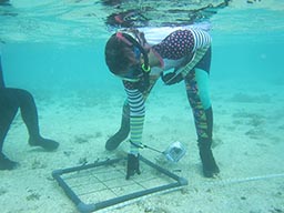
Finding Fish Hotspots and Mapping Coral Reefs
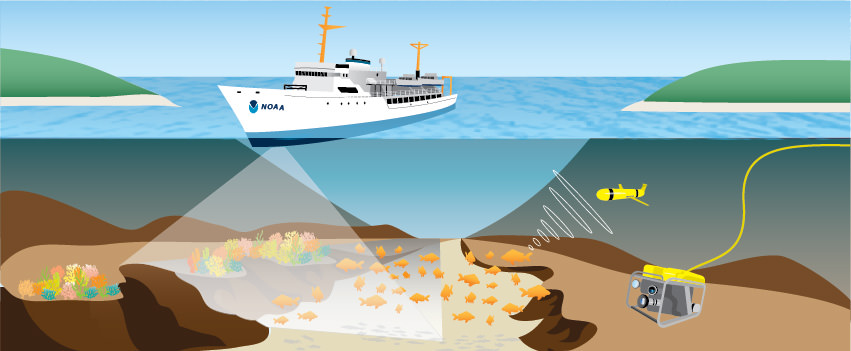
NOAA Expedition Marks Twelve Years of Discovery in the Caribbean
From March 28-April 7, NOAA scientists will lead the 12th year of an expedition to map the sea floor habitats and identify fish populations in portions of the U.S. Virgin Islands, putting NOAA one step closer to developing comprehensive habitat maps for the territory.
The team will deploy state-of-the-art technology including acoustic sonars, gliders and remotely operated vehicles complete with high-definition cameras from the NOAA Ship Nancy Foster to reach their goals. Much of the work will take place along the southern coast of St. Croix and off the northwest coast of St. Thomas, U.S. Virgin Islands. Efforts will also focus on two coastal areas important to commercial snapper fishing.
Along the way, the scientists will connect with local school groups, lawmakers, and marine resource managers to share their findings. They'll also highlight the strong partnerships NOAA has in the territory to support marine resource management and ocean planning in the U.S. Caribbean where so many communities and economies are tied to the ocean.
Stay tuned all week for updates from the field, podcasts, amazing underwater photos and videos, and more! Visit: http://oceanservice.noaa.gov/caribbean-mapping/
Partners include: NOAA Nationals Centers for Coastal Ocean Science, Coral Reef Conservation Program, National Ocean Service Communications and Education Division, U.S. Virgin Islands Department of Planning and Natural Resources, University of the Virgin Islands, and more.
About Us

The NOAA Coral Reef Conservation Program was established in 2000 by the Coral Reef Conservation Act. Headquartered in Silver Spring, Maryland, the program is part of NOAA's Office for Coastal Management.
The Coral Reef Information System (CoRIS) is the program's information portal that provides access to NOAA coral reef data and products.
Work With US
U.S. Coral Reef Task Force
Funding Opportunities
Employment
Fellowship Program
Contracting Assistance
Graphic Identifier
Featured Stories Archive
Access the archive of featured stories here...
Feedback
Thank you for visiting NOAA’s Coral Reef Conservation Program online. Please take our website satisfaction survey. We welcome your ideas, comments, and feedback. Questions? Email coralreef@noaa.gov.
Stay Connected
Contact Us
NOAA’s Coral Reef Conservation Program
SSMC4, 10th Floor
1305 East West Highway
Silver Spring, MD 20910
coralreef@noaa.gov