
- ABOUT US
- PROGRAM AREAS
- CONSERVATION APPROACH
- EDUCATION
- MULTIMEDIA
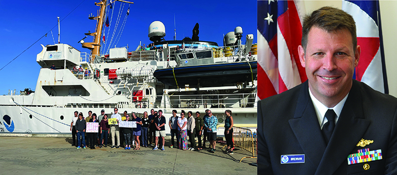
Successful Pacific coral reef and mapping mission honoring NOAA leader comes to end
By: Erica K. Towle, Ph.D., National Coral Reef Monitoring Program Coordinator
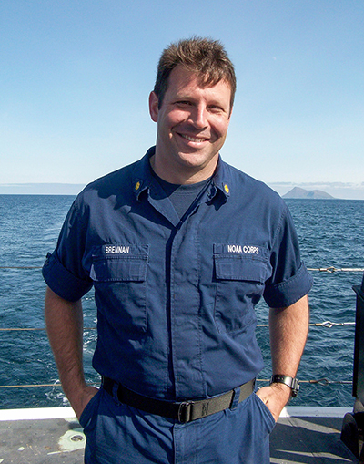
Takeaway: RICHARD stands for Rainier Integrates Charting Hydrography and Reef Demographics and refers to a first-of-its-kind collaborative mission between NOAA's Coral Reef Conservation Program and NOAA's Office of Coast Survey that occurred over two years in two Pacific Islands regions—the Marianas archipelago in 2022 and American Samoa and the Pacific Remote Island Areas in 2023. Rear Admiral Richard Brennan was the greatest champion of this mission, and the two cruises would not have been possible without his vision and leadership.
The making of the RICHARD mission
You might presume that scientists who predominantly work on mapping and charting in the Pacific Northwest and Alaska would never be on the same mission as scientists who work on coral reef ecology in the Pacific Islands, but the RICHARD missions brought those two groups (and more!) together over the course of four years of planning for two incredible years of missions aboard NOAA Ship Rainier. RICHARD stands for Rainier Integrates Charting Hydrography and Reef Demographics and refers to a first-of-its-kind collaborative mission between NOAA's Coral Reef Conservation Program (CRCP) and NOAA's Office of Coast Survey that occurred over two years in two Pacific Islands regions—the Marianas archipelago in 2022, and American Samoa and the Pacific Remote Island Areas in 2023. So, how did this epic collaboration come about?
Following the 2018 field season, it became clear that one of the ships in the NOAA fleet, NOAA Ship Hi’ialakai, would have to come offline due to its age and condition. This ship was the predominant research vessel for the mission of the National Coral Reef Monitoring Program (NCRMP) in the Pacific Islands. NCRMP is the nation's premier coral reef ecosystem monitoring program, designed to capitalize on the diverse expertise of different NOAA line offices and programs. NOAA's Coral Reef Conservation and Ocean Acidification Programs, and climate, fisheries, and coral reef scientists from NOAA's Pacific Islands Fisheries Science Center (PIFSC) live aboard the ship while conducting diver based NCRMP surveys across the Pacific. NCRMP provides some of the only data we have on coral reefs in the Pacific Islands—particularly in very remote parts of the U.S. Exclusive Economic Zone that cannot be accessed without ocean-going research vessels. Following Hi’ialakai’s final field season, NCRMP worked across NOAA programs and offices to accomplish the critical mission without a dedicated ship.
Working together across different NOAA missions
The Office of Coast Survey is the nation's authoritative nautical chart-maker. Coast Survey is responsible for surveying the seafloor to update nautical charts, locate underwater obstructions that are a danger to navigation, provide bathymetric depth data for coastal resilience, and more. Coast Survey relies heavily on ships and acoustic sensors to acquire bathymetry and seafloor data. NOAA Ship Rainier is one such ship in NOAA's fleet; it came online in 1968 to primarily focus on surveying Alaskan and Pacific waters.
By 2019, interest was growing to map the Pacific Islands for national security, so the loss of the Hi’ialakai was a big blow. At the same time, Coast Survey was fully committed to the global mapping campaign SeaBed 2030, with a stated goal to completely map the ocean floor by 2030. Many remote parts of the U.S. Pacific Islands were unmapped or mapped with obsolete technologies, making them excellent candidates for modern mapping data collection. NOAA Corps Rear Admiral Richard "Rick" Brennan, then a Captain and Chief of Coast Survey's Hydrographic Services Division, saw an opportunity to provide U.S. flag ship presence in the region, improve much-needed Pacific Island nautical charts, and help colleagues in CRCP accomplish their National Coral Reef Monitoring Program mission. So began the extensive discussions and planning that led to what became the RICHARD missions.
This was an incredible feat to accomplish. What started as a brainstorming session with six people in a small conference room in the spring of 2019 eventually led to engaging countless staff at various levels across NOAA over the course of four years, including the highest levels of leadership at NOAA's Fleet Council. While many staff contributed to the successful planning of the mission, the true shepherd of the initiative was Admiral Brennan, who was a Rear Admiral and Director of Coast Survey by the time of the 2021 monitoring season. Rear Admiral Brennan was a strong supporter of Integrated Ocean and Coastal Mapping, with a vision and energy for how the NOAA fleet could be more collaborative and interdisciplinary. He liked to think outside the box and find solutions to complex problems. Most of all, he loved using science as a pursuit to better our nation.
It was not easy at first. Some staff originally had concerns about redirecting the ship from the under-surveyed waters of Alaska. Other staff worried about how to accomplish a dive-intensive mission on a ship that traditionally did not support diving at that scale, in an unfamiliar region. Through many long and sometimes difficult conversations, staff persisted and worked together to develop a mission plan that would hit the mark for both programs. This first-ever collaboration in the Marianas Archipelago was set to commence during the 2020 field season. However, due to the emergence of the global COVID-19 pandemic, the mission was postponed two days before it was scheduled to begin, and wouldn't resume again until 2022.
Tragically, the unimaginable happened during this pause. In May 2021, Rear Adm. Rick Brennan passed away unexpectedly. The loss of Rear Admiral Brennan shook the entire NOAA family. Rick was a pillar within Coast Survey and the international hydrographic community, and was also loved by the NOAA Corps and many other NOAA staff across the agency. Rick never got to see his vision for the joint mission come to fruition, but his legacy was honored by naming the missions after him—RICHARD. This speaks volumes to the kind of person Rick was - it was unanimous that his name was the right one for the joint missions.
After long pause, monitoring and mapping across the Pacific Islands resumes
RICHARD I - Marianas
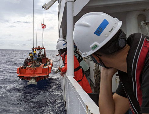
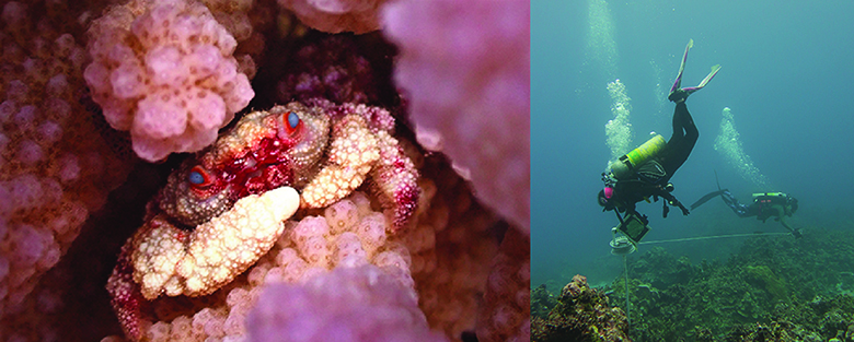
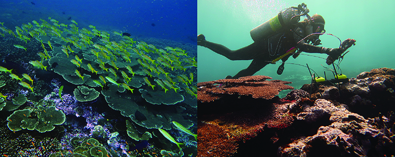
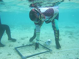
After two years of waiting, the Rainier commenced surveying and coral monitoring in the Mariana islands region, including Guam and the Commonwealth of the Northern Mariana Islands in April of 2022. The RICHARD mission continued for five months with scientists surveying 14 islands and banks throughout the archipelago, completing more than 1,600 scientific dives, and conducting hydrographic mapping work for over 7,000 linear nautical miles. The data from NCRMP will help local managers understand how the reefs and ocean conditions are changing over time, and what they can do to help them thrive. These data will also help inform local coral reef fisheries management plans by providing long-term data on target coral reef fisheries that the community depends on. The hydrographic mapping data from Coast Survey is foundational to understand the region and will be used to update nautical charts to promote safe navigation for vessels. These data will also improve models predicting sea level rise, coastal flooding, and tsunami impacts.
RICHARD II - American Samoa and the Pacific Remote Island Areas
In 2023, the RICHARD II cruise covered the central and south Pacific where NOAA scientists from even more different backgrounds came together again on one mission to collect a wide variety of important data. NCRMP scientists collected long-term, high quality data on coral reef communities, fish populations, oceanographic conditions, and ocean chemistry to evaluate potential changes in coral reef health and structure and to inform the NOAA Ocean Acidification Program as on RICHARD I in the Marianas. The Office of Coast Survey collected high resolution bathymetric data to update nautical charting products to promote maritime safety, as well as seabed habitat characterization data, sea surface level measurements, and water-column temperature profiles also as on RICHARD I. The National Marine Sanctuary of American Sāmoa supported the Deep Coral Reef Ecosystem Studies Program with deep-sea coral ecosystem surveys at the remote islands of Swains and Taʻu, which was a new partner on Rainier for 2023. All in all, the RICHARD team aboard visited two archipelagos and eight island areas in the central and south Pacific during the 2023 mission.
It's hard to put into words the enormity of the success of these two unprecedented one-NOAA missions in the face of many logistical and operational challenges. The achievements of the scientists and crew speak for themselves with hundreds of days at sea, thousands of dives completed, and tens of thousands of linear nautical miles mapped. But more important than the quantitative metrics is the feeling of pride I have for honoring the legacy of a respected NOAA leader and friend. Some NCRMP colleagues spearheaded designing a commemorative cruise t-shirt every year that staff can order at the end of the field season. I like to think about how all of us who have a RICHARD t-shirt will continue to carry on a little of his legacy whenever we wear them.
Related Stories and Products
About Us

The NOAA Coral Reef Conservation Program was established in 2000 by the Coral Reef Conservation Act. Headquartered in Silver Spring, Maryland, the program is part of NOAA's Office for Coastal Management.
The Coral Reef Information System (CoRIS) is the program's information portal that provides access to NOAA coral reef data and products.
Work With US
U.S. Coral Reef Task Force
Funding Opportunities
Employment
Fellowship Program
Contracting Assistance
Graphic Identifier
Featured Stories Archive
Access the archive of featured stories here...
Feedback
Thank you for visiting NOAA’s Coral Reef Conservation Program online. Please take our website satisfaction survey. We welcome your ideas, comments, and feedback. Questions? Email coralreef@noaa.gov.
Stay Connected
Contact Us
NOAA’s Coral Reef Conservation Program
SSMC4, 10th Floor
1305 East West Highway
Silver Spring, MD 20910
coralreef@noaa.gov